Melbourne and the 2004 hurricane double-strike: Frances and Jeanne
In a single twenty-day stretch in September 2004, Hurricanes Frances and Jeanne hit Melbourne with sustained tropical-storm conditions that lasted over a hundred hours combined. Here's what happened and how the city rebuilt.
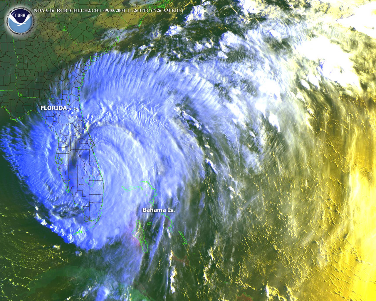
In a roughly twenty-day stretch in September 2004, Melbourne was hit twice by hurricanes. Hurricane Frances made landfall at Sewall’s Point in Martin County (about 60 miles south of Melbourne) on September 5, 2004, then slow-tracked north-northwest across the state with the storm’s strongest right-side bands lashing south Brevard for over thirty hours. Hurricane Jeanne made landfall near nearly the same location on September 26, 2004, again slow-tracking north across the state. The two storms together produced cumulative sustained tropical-storm winds at Melbourne of more than 100 hours, peak gusts well over hurricane force, and storm surge that pushed the Indian River Lagoon over its banks in multiple locations.
The 2004 season is the defining modern weather event in Melbourne’s history. This article walks through both storms and what they did.
The setup
The 2004 Atlantic hurricane season was unusually active, with 15 named storms and 9 hurricanes (6 of them major, Category 3+). Florida received four hurricanes in the span of six weeks: Charley (August 13, southwest Florida), Frances (September 5), Ivan (September 16, Florida Panhandle), and Jeanne (September 26). Of these, Frances and Jeanne were the storms that directly affected Melbourne.
The state’s emergency management infrastructure was severely stressed by the cumulative load. Power crews from neighboring states had been deployed to handle Charley’s damage and had not fully returned when Frances arrived. Insurance adjusters were overwhelmed. Construction materials were short. Cumulative damage from successive storms compounded faster than recovery could keep up.
Hurricane Frances
Frances was a large slow-moving Category 2 hurricane at Florida landfall (it had been a major Category 4 in the Bahamas the day before but weakened significantly). The storm’s center came ashore at Sewall’s Point on the night of September 4-5, 2004. The eye crossed into Florida at about 1:00 AM local time on September 5.
Melbourne was on the right (north) side of the storm. Right-side tropical cyclone winds are typically the strongest because the storm’s forward motion adds to its rotational winds. Melbourne experienced:
- Sustained winds in the 60 to 80 mph range for most of September 5.
- Peak gusts measured at 105 mph at Melbourne International Airport and 110 mph at Patrick AFB during the worst hours.
- Rainfall totaling 8 to 12 inches over the storm’s passage.
- Storm surge in the Indian River Lagoon of about 4 to 6 feet above normal high tide, with flooding in low-lying neighborhoods and along the Crane Creek waterfront.
The storm was unusually large and slow. Melbourne was in tropical-storm-force winds (39+ mph sustained) for approximately 36 hours. That extended duration mattered more than peak winds for damage purposes. Roofs that would have survived a few hours of 80 mph winds didn’t survive 36 hours.
Damage in Melbourne was extensive. Estimated city-wide:
- Roofs damaged or destroyed: tens of thousands of homes. The asphalt-shingle roofs typical of mid-twentieth-century Florida construction were particularly vulnerable.
- Trees down: hundreds of thousands across Brevard. Many large oaks, ficus, and palms in the historic neighborhoods came down.
- Power outages: nearly 100% of Brevard County customers lost power for some period. Some outages lasted 7 to 10 days.
- Public infrastructure damage: schools, parks, government facilities. The Henegar Center sustained roof and water damage. The Eau Gallie Causeway had bridge approach issues. Crane Creek docks were damaged.
- Direct fatalities in Brevard: small (single digits), most from indirect causes (heart attacks, accidents during cleanup) rather than direct storm trauma.
Three weeks of recovery
The interlude between Frances and Jeanne was three weeks. In that time:
- Power was gradually restored, with full restoration of metropolitan Brevard achieved by about September 14-15.
- Tarps and emergency roof repairs covered the most vulnerable damage.
- Schools were closed for most of the recovery period, reopening in stages.
- Insurance claims processing began. Adjusters faced enormous backlogs.
- Cleanup of vegetation debris started but was nowhere near complete.
The community was still actively recovering when Jeanne formed in the Atlantic and threatened a second strike.
Hurricane Jeanne
Jeanne made landfall on September 26, 2004, again at almost exactly the same Martin County location as Frances. The track and intensity were similar: Category 3 at landfall, slow-tracking northwest across the state. Melbourne again experienced right-side conditions for approximately 30 hours.
Specific Jeanne impacts at Melbourne:
- Sustained winds in the 60 to 75 mph range for 24+ hours.
- Peak gusts around 95-100 mph, slightly lower than Frances.
- Rainfall of 6 to 10 inches, falling onto already-saturated ground.
- Storm surge similar to Frances, with continued flooding of low-lying areas.
The cumulative effect of Frances + Jeanne on damaged structures was severe. Homes with tarped roofs lost their tarps. Roof damage that had been temporarily mitigated reopened. Vegetation that had been weakened by Frances came down in Jeanne. Power that had been restored after Frances was lost again with Jeanne and took another full week to restore.
The total cumulative Brevard County damage from Frances + Jeanne was estimated at $1.5 to $2.5 billion in 2004 dollars (approximately $2.5 to $4.2 billion in 2026 dollars). It was the costliest weather event in Brevard County history to that point.
What recovery looked like
The recovery from the 2004 season was a multi-year effort.
Insurance. Homeowners insurance in Florida changed dramatically after 2004. The state’s insurance market, already strained, was significantly disrupted. Multiple insurers withdrew from Florida or restricted writing new policies. State-backed Citizens Property Insurance grew substantially. Premiums rose sharply.
Building codes. Florida had already strengthened its building codes significantly after Hurricane Andrew in 1992. The 2004 storms validated those upgrades; structures built to post-Andrew codes generally performed much better than older structures. The 2004 experience reinforced code stringency and led to additional updates.
FEMA and federal disaster assistance. Brevard County received substantial federal disaster declarations and FEMA assistance. Public Assistance funds went to rebuilding government and school infrastructure. Individual Assistance went to homeowners and renters. The total federal aid to Brevard was in the hundreds of millions.
Vegetation recovery. Many of the historic-neighborhood trees took decades to recover. Some of the largest oaks in downtown Melbourne never came back; replacement plantings are still maturing twenty years later.
Roof and structure repair. The visible repair work continued through 2005, 2006, and 2007. Some lower-income neighborhoods had visible blue tarps for years after the storms.
What 2004 taught Melbourne
Three lessons worth recording.
Slow-moving large storms are the danger. Frances and Jeanne were not exceptionally strong by hurricane standards (both were Category 2 at landfall). They did exceptional damage because they were large and slow, with extended duration of tropical-storm-force winds. Future planning has increasingly focused on storm forward speed as a key risk variable in addition to peak winds.
Successive storms compound dramatically. A community that’s still recovering from one storm is much more vulnerable to a second. The 2004 season made this clear at Melbourne. Recovery infrastructure (utility crews, building materials, contractor capacity) is finite. Stretched across multiple events, it falls apart.
Building codes matter. Post-Andrew Florida codes saved Brevard from worse outcomes in 2004. The investment in stricter building standards through the 1990s paid off.
The 2004 storms remain the modern reference point. Subsequent Brevard storms (Matthew 2016, Irma 2017, Nicole 2022, Milton 2024) have been compared against Frances and Jeanne. None has been as bad. But the season is the baseline against which all subsequent storms are evaluated.
Sources
- NOAA National Hurricane Center, “Hurricane Frances” and “Hurricane Jeanne” tropical cyclone reports, 2005. https://www.nhc.noaa.gov/
- Brevard County Emergency Management, 2004 storm damage assessments, accessed 2026-01-24. https://www.brevardfl.gov/EmergencyManagement
- Florida Memory Project, 2004 hurricane season photographs and recovery documentation, accessed 2026-01-24. https://www.floridamemory.com/
- FEMA, Brevard County disaster declarations and assistance summaries 2004-2007.
- Florida Office of Insurance Regulation, market disruption reports post-2004.
- Florida Building Commission, building code changes 2005-2010 timeline.
Further Reading
As an Amazon Associate we earn from qualifying purchases.